For municipalities, schools and parents
The route map: the school route plan to click on
With the route map, the finished school route plan appears as an interactive map on the website of the municipality or the school. Parents tap a spot to read what their child should watch out for, or let the map show them the way from their street to school. Everything sits on the municipality's server, without requests to Zebrio or any other service.
Just the map, on any page
The route map shows the plan and nothing else: recommended routes, dangerous spots, zebra crossings, crossing guards and meeting points. Tapping a symbol opens its description, on a phone as a small window over the map, on wide pages in a panel beside it. The map adapts to the space it gets, from a narrow content column to the full width of the page.
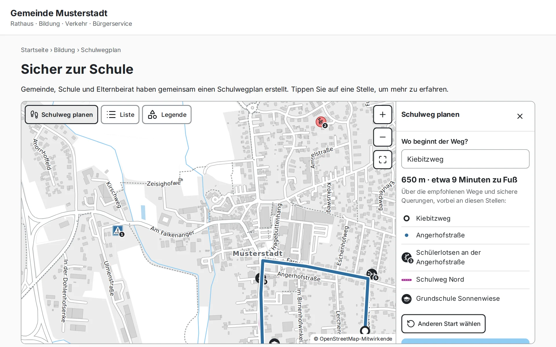
Plan the way to school: from your own street
Parents enter where their child's way begins, or tap the map. The route map shows the way to school along the plan's recommended routes and safe crossings, with its length, the walking time and the spots where their child should take care. The plan for everyone becomes the way for your own child.
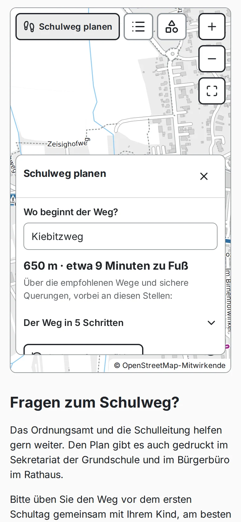
How parents plan the way
Tap "Schulweg planen" (plan the way to school) and enter the street where the way begins, or tap the spot on the map.
The map shows the way to school. It follows the recommended routes and crosses the streets where the plan says to.
Beside it are the streets in order, the length and walking time, and the spots on the way, such as a zebra crossing or the crossing guards.
Walk the way with your child and practise it, ideally at the same time of day as later.
Easy to use
On phones and computers
Large buttons. One finger scrolls the page, two fingers move the map; on a computer, Ctrl and the mouse wheel zoom.
In any column width
On a narrow map, descriptions open in a window over the map; on a wide one, in a panel beside it.
Everything as a list too
"Liste" shows every route and spot as text, "Legende" explains the symbols. The plan is complete even without the map.
Accessible
Works with a keyboard and screen readers, with a clearly visible focus and sufficient contrast, tested against WCAG 2.2 AA.
The plan's symbols
The same symbols and numbers as in the printed school route plan, so the map, the list and the printout match.
Always up to date
When the plan changes, the municipality replaces one file. The list says who publishes the plan and how recent it is.
What the route map looks like on a website
How the map gets onto your website
Open the finished plan in the planning tool and choose "Für die Website" (for the website). The map file is made in the browser.
Upload the map file and the route map's two files to the server of the municipality or school, just like a PDF or an image.
Add two lines to the page. Where the content management system allows no scripts, an embedded frame (iframe) works too.
When the plan changes, replace only the map file.
No request to Zebrio
The map, the map data and the plan sit on the municipality's server. Visitors load nothing from Zebrio or any other service; there are no cookies and no statistics. The start parents enter in "Schulweg planen" stays on their device. The map holds only the plan, no survey results and no routes of individual children.
Good to know
- No requests to Zebrio or other services
- No cookies, no tracking
- The start you plan from stays on your device
- Only the plan, no survey data
- The planning toolDraw a school route plan from the results, print it and pass it on.
- Practising the way to schoolChoose the safest route and practise it with your child step by step.
- Creating a school route planHow a parents' survey provides the basis for the walking and cycling route plan.
- For municipalities and traffic authoritiesReport, maps and GIS data for site inspections and planning.
Zebrio at your school too?
Schools, parents' councils and municipalities that would like to run a school route survey can simply send us an email. We answer your questions and set up the survey for the school.